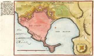
Antibes, Eine Stadt und Meerhafen
Bodenehr, Gabriel.
Antibes, Eine Stadt und Meerhafen.
Augsburg, 1725.
Original engraving with later hand-coloring.
Sheet size: 7 3/4 x 13 in.
Item nr. 158531
Price: $400.00
Bodenehr, Gabriel.
Antibes, Eine Stadt und Meerhafen.
Augsburg, 1725.
Original engraving with later hand-coloring.
Sheet size: 7 3/4 x 13 in.
Item nr. 158531
Price: $400.00
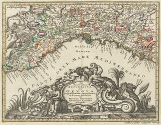
Seutter, Matthew.
Genova [Genoa].
Atlas minor praecipua Terrarum Imperia...
Augsburg, circa 1744.
Original engraving with old hand-coloring.
Sheet size: 8 1/4 x 12 3/4 in.
Item nr. 157942
Price: $650.00
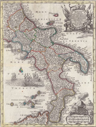
Seutter, Matthew.
Neapolis Regnum [Southern Italy].
Atlas minor praecipua Terrarum Imperia...
Augsburg, circa 1744.
Original engraving with old hand-coloring.
Sheet size: 8 1/4 x 12 3/4 in.
Item nr. 157917
Price: $650.00
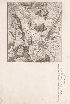
Le Rouge, George Louis.
Jardins Anglo-Chinois à la Mode.
This plate: Cahier 8, Plate 1. a Paris, Chez Le Rouge, Rue des Grands Augustins. [Munich].
Paris, 1776-88.
Original engraving with later hand-coloring.
Sheet size: 11 1/8 x 16 1/4 in.
Item nr. 157385
Price: $285.00 save 50% $142.50
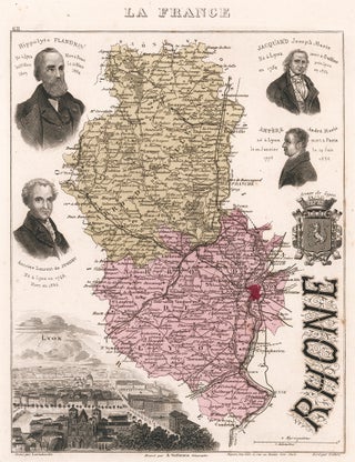
Vuillemin, Alexandre.
La France et ses colonies, Atlas Illustre.
This plate: Rhone.
Original hand-colored engraving.
Paris, 1874.
Sheet size: 13 1/3 x 10 in.
Item nr. 156914
Price: $200.00
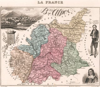
Vuillemin, Alexandre.
La France et ses colonies, Atlas Illustre.
This plate: B. ses Alpes.
Original hand-colored engraving.
Paris, 1874.
Sheet size: 10 x 13 1/3 in.
Item nr. 156911
Price: $200.00
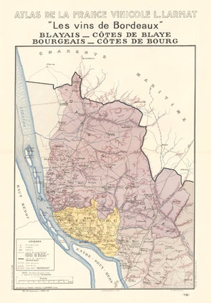
Larmat, Louis.
Atlas de la France Vinicole.
This plate: Les vins de Bordeaux (Blayais - Cotes de Blaye et Bourgeais - Cotes de Bourg).
Paris, Louis Larmat, 1943.
Sheet size: 25 1/4 x 17 1/2 in.
Item nr. 155444
Price: $300.00
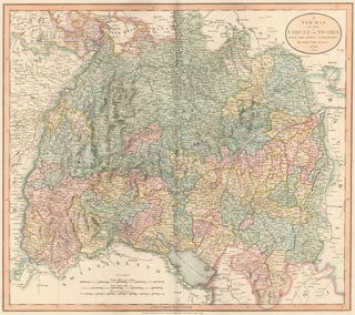
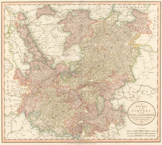
Cary, John.
Cary's New Universal Atlas.
This plate: A New Map of the Circle of Swabia. [Southwestern Germany.]
London, 1808. [Map dated 1799.]
Original engraving hand-colored at publication.
Sheet size: 21 x 26 in.
Item nr. 154535
Price: $585.00
Cary, John.
Cary's New Universal Atlas.
This plate: A New Map of the Circles of the Upper and Lower Rhine.
London, 1808. [Map dated 1799.]
Original engraving hand-colored at publication.
Sheet size: 21 x 26 in.
Item nr. 154530
Price: $585.00
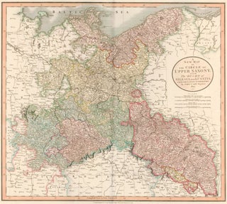
Cary, John.
Cary's New Universal Atlas.
This plate: A New Map of the Circle of Upper Saxony; with the Duchy of Silesia and Lusatia. [Germany.]
London, 1808. [Map dated 1801.]
Original engraving hand-colored at publication.
Sheet size: 21 x 26 in.
Item nr. 154529
Price: $485.00
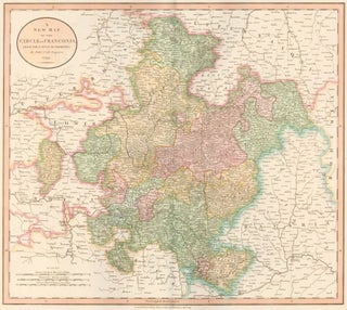
Cary, John.
Cary's New Universal Atlas.
This plate: A New Map of the Circle of Franconia.[Germany.]
London, 1808. [Map dated 1799.]
Original engraving hand-colored at publication.
Sheet size: 21 x 26 in.
Item nr. 154526
Price: $585.00
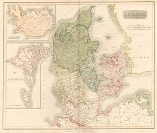
Thomson, John.
Denmark, including the Feroe Islands and Iceland. New General Atlas.
Edinburgh, Thomson, 1817.
Original engraving hand-colored at publication.
Sheet size: 21 x 26 in.
Item nr. 154525
Price: $585.00
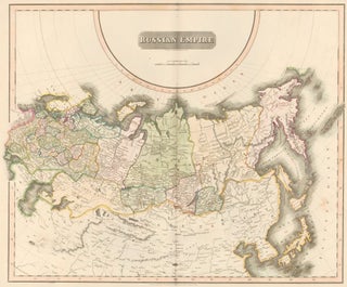
Thomson, John.
Russian Empire. New General Atlas.
Edinburgh, Thomson, 1817.
Original engraving hand-colored at publication.
Sheet size: 21 x 26 in.
Item nr. 154518
Price: $950.00
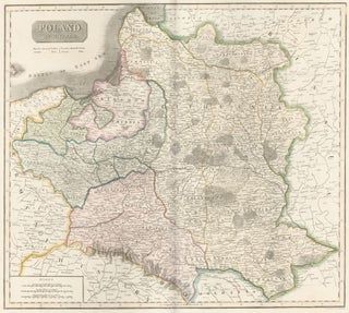
Thomson, John.
Poland. New General Atlas.
Edinburgh, Thomson, 1817.
Original engraving hand-colored at publication.
Sheet size: 21 x 26 in.
Item nr. 154513
Price: $385.00

Johnston, Alexander Keith.
The Cabinet Atlas of the World.
This plate: Sweden & Norway.
Edinburgh, W. & A.K. Johnston, 1878.
Sheet size: 12 1/4 x 9 3/4 in.
Item nr. 154031
Price: $300.00
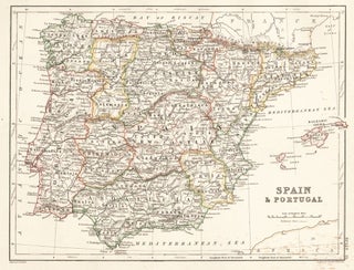
Johnston, Alexander Keith.
The Cabinet Atlas of the World.
This plate: Spain & Portugal.
Edinburgh, W. & A.K. Johnston, 1878.
Sheet size: 9 3/4 x 12 1/4 in.
Item nr. 154030
Price: $300.00
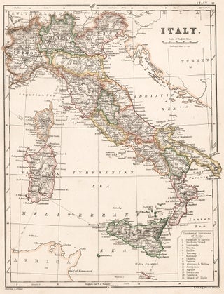
Johnston, Alexander Keith.
The Cabinet Atlas of the World.
This plate: Italy.
Edinburgh, W. & A.K. Johnston, 1878.
Sheet size: 12 1/4 x 9 3/4 in.
Item nr. 154029
Price: $300.00
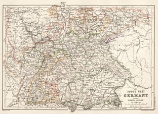
Johnston, Alexander Keith.
The Cabinet Atlas of the World.
This plate: South West Germany.
Edinburgh, W. & A.K. Johnston, 1878.
Sheet size: 9 3/4 x 12 1/4 in.
Item nr. 154027
Price: $300.00
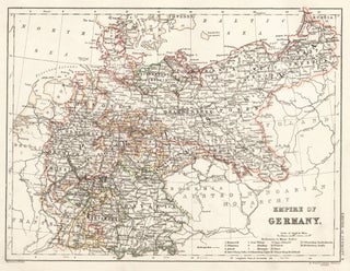
Johnston, Alexander Keith.
The Cabinet Atlas of the World.
This plate: Empire of Germany.
Edinburgh, W. & A.K. Johnston, 1878.
Sheet size: 9 3/4 x 12 1/4 in.
Item nr. 154025
Price: $300.00
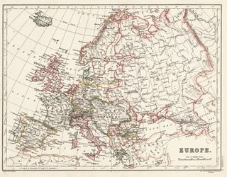
Johnston, Alexander Keith.
The Cabinet Atlas of the World.
This plate: Europe.
Edinburgh, W. & A.K. Johnston, 1878.
Sheet size: 9 3/4 x 12 1/4 in.
Item nr. 154013
Price: $300.00
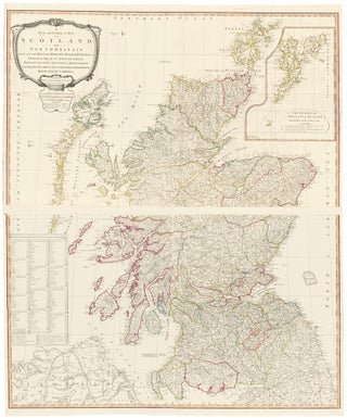
Kitchin, Thomas.
A New Universal Atlas.
London, Laurie & Whittle, 1798.
Original engraving hand-colored at publication.
This plate: 10 & 11. Scotland.
Sheet size:
Plate 10: 26 x 43 in.
Plate 11:6 x 43 in.
Item nr. 153168
Price: $2,400.00
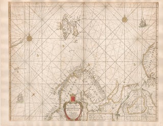
Jansson, Jan.
Ruslant, Laplant, Finmarcken... [Russia, Lapland, Finland, Spitsberg]
Amsterdam, 1654-7.
Original engraving hand-colored at publication.
Sheet size: 18 1/2 x 23 7/8 in.
Item nr. 152667
Price: $950.00
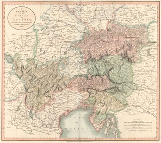
Cary, John.
Cary's New Universal Atlas.
This plate: A New Map of the Circle of Austria.
London, 1808. [Map dated 1801.]
Original engraving hand-colored at publication.
Sheet size: 21 x 26 in.
Item nr. 130794
Price: $585.00
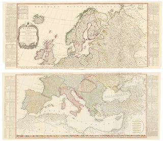
Kitchin, Thomas.
Europe. A New Universal Atlas.
London, Laurie & Whittle, 1798.
Original engravings hand-colored at publication.
Sheet sizes:
Plate 4: 21 1/4 x 50 in.
Plate 5: 21 1/4 x 50 in.
Item nr. 127518
Price: $3,200.00
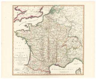
Kitchin, Thomas.
France. A New Universal Atlas.
London, Laurie & Whittle, 1798.
Original engraving hand-colored at publication.
Sheet size: 29 1/2 x 21 1/4 in.
Item nr. 127517
Price: $950.00