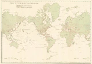
The Main Trunk Air Routes of the World
U.S. Coast Guard.
The Main Trunk Air Routes of the World.
Washington, D.C., 1933.
Original lithograph.
Item nr. 162640
Price: $300.00
U.S. Coast Guard.
The Main Trunk Air Routes of the World.
Washington, D.C., 1933.
Original lithograph.
Item nr. 162640
Price: $300.00
![Item nr. 162430 Western Hemisphere [North and South America, New Zealand]. Thomson's New General...](https://ursusbooks.cdn.bibliopolis.com/pictures/162430.jpg?width=320&height=427&fit=bounds&auto=webp&v=1557791012)
Thomson, John.
Thomson's New General Atlas.
This plate: Western Hemisphere.
London, Neele, 1815.
Sheet size: 26 3/8 x 21 in.
Item nr. 162430
Price: $685.00
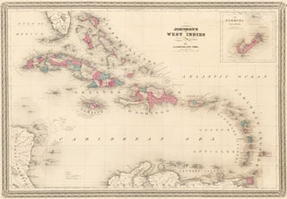
Johnson, Alvin J.
Johnson's New Illustrated Family Atlas of the World.
This plate: Johnson's West Indies, (inset) The Bermuda Islands.
New York, 1870.
Original engraving, with hand-coloring.
Sheet size: 18 x 26 3/4 in.
Item nr. 162429
Price: $300.00
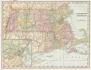
Cram, George Franklin.
Cram's Unrivaled Atlas of the World.
This plate: Massachusetts and Rhode Island.
Chicago, 1889.
Original lithograph printed in color.
Sheet size: 11 x 14 1/2 in.
Item nr. 162272
Price: $285.00
![Item nr. 162210 Map showing the Territorial Growth of the United States [1776-1887]. Cram's...](https://ursusbooks.cdn.bibliopolis.com/pictures/162210.jpg?width=320&height=427&fit=bounds&auto=webp&v=1444446263)
Cram, George Franklin.
Cram's Unrivaled Atlas of the World.
This plate: Map showing the Territorial Growth of the United States [1776-1887].
Chicago, 1889.
Original lithograph printed in color.
Sheet size: 11 1/2 x 14 1/2 in.
Item nr. 162210
Price: $285.00
![Item nr. 162209 United States in Peace [1865-1889]. Cram's Unrivaled Atlas of the World. George...](https://ursusbooks.cdn.bibliopolis.com/pictures/162209.jpg?width=320&height=427&fit=bounds&auto=webp&v=1444446263)
Cram, George Franklin.
Cram's Unrivaled Atlas of the World.
This plate: United States in Peace [1865-1889].
Chicago, 1889.
Original lithograph printed in color.
Sheet size: 11 1/2 x 14 1/2 in.
Item nr. 162209
Price: $285.00
![Item nr. 162202 The Americas [1491-1886]. Cram's Unrivaled Atlas of the World. George Franklin Cram](https://ursusbooks.cdn.bibliopolis.com/pictures/162202.jpg?width=320&height=427&fit=bounds&auto=webp&v=1444433589)
Cram, George Franklin.
Cram's Unrivaled Atlas of the World.
This plate: The Americas [1491-1886].
Chicago, 1889.
Original lithograph printed in color.
Sheet size: 11 1/2 x 14 1/2 in.
Item nr. 162202
Price: $285.00
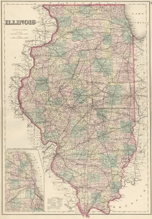
Gray and Son, O.W.
Illinois.
Philadelphia, ca. 1878.
Lithograph.
Sheet size: 25 5/8 x 16 7/8 in.
Item nr. 162059
Price: $125.00
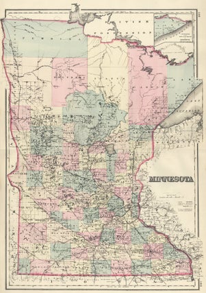
Gray and Son, O.W.
Minnesota.
Philadelphia, ca. 1878.
Lithograph.
Sheet size: 28 1/8 x 17 1/4 in.
Item nr. 162057
Price: $125.00
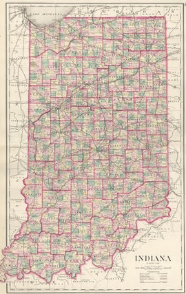
Gray, Frank A.
Indiana.
Philadelphia, ca. 1878.
Lithograph.
Sheet size: 28 x 17 1/4 in.
Item nr. 162056
Price: $125.00
Bardwell, W. and J. H. Taylor.
Report on Metropolis Improvements.
This plate: Detail Plan of the Proposed Thorofares Showing the Houses to be Taken Down.
London, James and Luke G. Hansard & Sons, 1838.
Original lithograph, hand-colored at publication.
Sheet size: 13 1/8 x 23 7/8 in.
Item nr. 161838
Price: $485.00
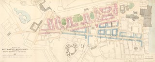
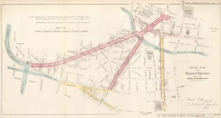
Bardwell, W. and J. H. Taylor.
Report on Metropolis Improvements.
This plate: Plan of Westminster Improvements.
London, James and Luke G. Hansard & Sons, 1838.
Original lithograph, hand-colored at publication.
Sheet size: 13 3/4 x 30 in.
Item nr. 161837
Price: $525.00
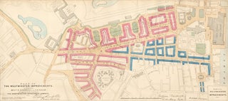
Bardwell, W. and J. H. Taylor.
Report on Metropolis Improvements.
This plate: Plan of Westminster Improvements.
London, James and Luke G. Hansard & Sons, 1838.
Original lithograph, hand-colored at publication.
Sheet size: 13 3/4 x 30 in.
Item nr. 161835
Price: $525.00
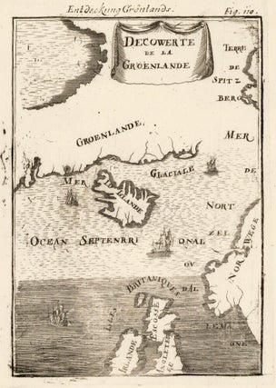
Mallet, Allain Manesson.
Description de l'Univers.
Frankfurt, Chez Jean David Zunner, 1685.
This plate: Fig. 110. Map of Greenland.
Copperplate engraving.
Sheet size: 7 3/4 x 6 in.
Image size: 5 1/2 x 3 7/8 in.
Item nr. 160484
Price: $385.00
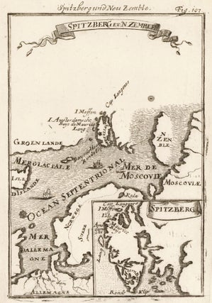
Mallet, Allain Manesson.
Description de l'Univers.
Frankfurt, Chez Jean David Zunner, 1685.
This plate: Fig. 107. Spitsbergen and Novaya Zemlya.
Copperplate engraving.
Sheet size: 7 3/4 x 6 in.
Image size: 5 1/2 x 3 7/8 in.
Item nr. 160481
Price: $385.00
![Item nr. 160480 Staten-Eyeland and Isle Maurice [Russian Arctic Islands]. Description de...](https://ursusbooks.cdn.bibliopolis.com/pictures/160480.jpg?width=320&height=427&fit=bounds&auto=webp&v=1434065508)
Mallet, Allain Manesson.
Description de l'Univers.
Frankfurt, Chez Jean David Zunner, 1685.
This plate: Fig. 106. Staten-Eyeland and Isle Maurice [Russian Arctic Islands].
Copperplate engraving.
Sheet size: 7 3/4 x 6 in.
Image size: 5 1/2 x 3 7/8 in.
Item nr. 160480
Price: $385.00
Mallet, Allain Manesson.
Description de l'Univers.
Frankfurt, Chez Jean David Zunner, 1685.
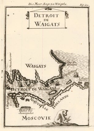
This plate: Fig. 105. Yugorsky Strait map.
Copperplate engraving.
Sheet size: 7 3/4 x 6 in.
Image size: 5 1/2 x 3 7/8 in.
Item nr. 160479
Price: $385.00
![Item nr. 160478 Map of Novaya Zemlya [Nova Zembla], Russia. Description de l'Univers. Allain...](https://ursusbooks.cdn.bibliopolis.com/pictures/160478.jpg?width=320&height=427&fit=bounds&auto=webp&v=1434065506)
Mallet, Allain Manesson.
Description de l'Univers.
Frankfurt, Chez Jean David Zunner, 1685.
This plate: Fig. 101. Map of Novaya Zemlya [Nova Zembla], Russia.
Copperplate engraving.
Sheet size: 7 3/4 x 6 in.
Image size: 5 1/2 x 3 7/8 in.
Item nr. 160478
Price: $385.00
![Item nr. 160477 Map of Hokkaido [Yesso], Japan. Description de l'Univers. Allain Manesson Mallet](https://ursusbooks.cdn.bibliopolis.com/pictures/160477.jpg?width=320&height=427&fit=bounds&auto=webp&v=1434065505)
Mallet, Allain Manesson.
Description de l'Univers.
Frankfurt, Chez Jean David Zunner, 1685.
This plate: Fig. 100. Map of Hokkaido [Yesso], Japan.
Copperplate engraving.
Sheet size: 7 3/4 x 6 in.
Image size: 5 1/2 x 3 7/8 in.
Item nr. 160477
Price: $385.00
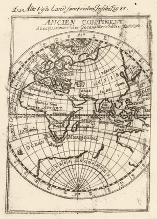
Mallet, Allain Manesson.
Description de l'Univers.
Frankfurt, Chez Jean David Zunner, 1685.
This plate: Fig. 85. Ancient continent with several islands, oceans, and seas.
Copperplate engraving.
Sheet size: 7 3/4 x 6 in.
Image size: 5 1/2 x 3 7/8 in.
Item nr. 160475
Price: $385.00
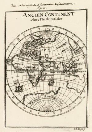
Mallet, Allain Manesson.
Description de l'Univers.
Frankfurt, Chez Jean David Zunner, 1685.
This plate: Fig. 77. The Ancient Continent.
Copperplate engraving.
Sheet size: 7 3/4 x 6 in.
Image size: 5 1/2 x 3 7/8 in.
Item nr. 160471
Price: $385.00
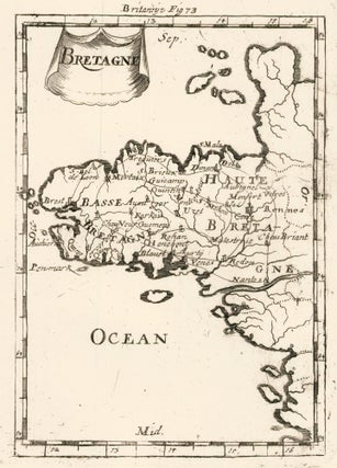
Mallet, Allain Manesson.
Description de l'Univers.
Frankfurt, Chez Jean David Zunner, 1685.
This plate: Fig. 73. Map of Brittany, France.
Copperplate engraving.
Sheet size: 7 3/4 x 6 in.
Image size: 5 1/2 x 3 7/8 in.
Item nr. 160468
Price: $385.00
Mallet, Allain Manesson.
Description de l'Univers.
Frankfurt, Chez Jean David Zunner, 1685.
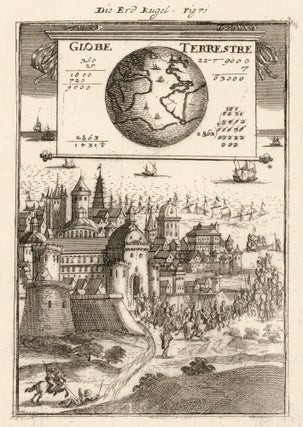
This plate: Fig. 71. Mass of Earth (land mass) compared to water mass.
Copperplate engraving.
Sheet size: 7 3/4 x 6 in.
Image size: 5 1/2 x 3 7/8 in.
Item nr. 160467
Price: $385.00
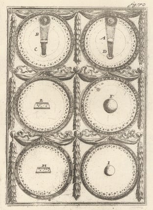
Mallet, Allain Manesson.
Description de l'Univers.
Frankfurt, Chez Jean David Zunner, 1685.
This plate: Fig. 70. Examples relating to land and water on Earth.
Copperplate engraving.
Sheet size: 7 3/4 x 6 in.
Image size: 5 1/2 x 3 7/8 in.
Item nr. 160465
Price: $385.00
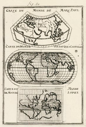
Mallet, Allain Manesson.
Description de l'Univers.
Frankfurt, Chez Jean David Zunner, 1685.
This plate: Fig. 68. Changes in world map constuction since the discovery of the Americas.
Copperplate engraving.
Sheet size: 7 3/4 x 6 in.
Image size: 5 1/2 x 3 7/8 in.
Item nr. 160464
Price: $385.00