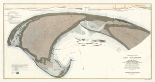
Comparative Map of Cape Cod Harbor..
Pierce, Benjamin.
Comparative Map of Cape Cod Harbor...
Philadelphia, Bowen & Co., 1867.
Original lithograph with hand-coloring.
Sheet size: 18 x 32 1/4 in.
Item nr. 160154
Price: $685.00
Pierce, Benjamin.
Comparative Map of Cape Cod Harbor...
Philadelphia, Bowen & Co., 1867.
Original lithograph with hand-coloring.
Sheet size: 18 x 32 1/4 in.
Item nr. 160154
Price: $685.00
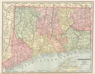
Cram, George Franklin.
Map of Connecticut.
Chicago, 1889.
Original lithograph printed in color.
Sheet size: 11 x 14 1/2 in.
Item nr. 158816
Price: $385.00
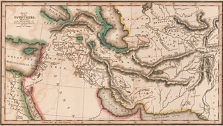
Palmer, Richard.
The Bible Atlas.
This plate: Countries mentioned in the Histories of Noah, Abraham and the Kings of Israel.
New York, 1836.
Original lithograph with hand coloring.
Sheet size: 8 1/4 x 11 3/4 in.
Item nr. 157445
Price: $400.00
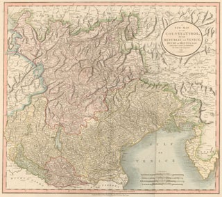
Cary, John.
Cary's New Universal Atlas.
This plate: A New Map of the County of Tyrol and the Republic of Venice; Duchy of Mantua...
London, 1808. [Map dated 1799.]
Original engraving hand-colored at publication.
Sheet size: 21 x 26 in.
Item nr. 50248
Price: $585.00
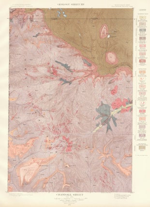
Hague, Arnold.
Atlas to Accompany Monograph XXXII on the Geology of the Yellowstone National Park.
This plate: Crandall Sheet.
Washington, 1904.
Original color lithograph.
Sheet size: 21 3/4 x 17 1/2 in.
Item nr. 159966
Price: $225.00
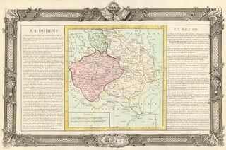
Clouet, Jean-Baptiste Louis.
Géographie Moderne.
Paris, 1787.
This plate: La Boheme.
Original engraving hand-colored at publication.
Sheet size: 19 3/4 x 26 3/4 in.
Item nr. 50154
Price: $500.00
![Item nr. 156127 De Stadt Visiapoer [Ancient city of Visapour in India]. Pieter Boudewyn van der...](https://ursusbooks.cdn.bibliopolis.com/pictures/156127.jpg?width=320&height=427&fit=bounds&auto=webp&v=1439003028)
van der Aa, Pieter Boudewyn.
De Stadt Visiapoer.
Leiden, ca. 1700.
Original engraving.
Plate size: 11 7/8 x 14 5/8 in.
Item nr. 156127
Price: $385.00
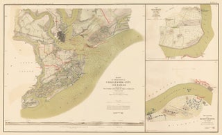
The United States War Department.
Atlas to Accompany the Official Records of the Union and Confederate Armies.
This plate: IV. Defenses of city and harbor, Charleston, S. C., 1863-65; Belmont, Mo., November 7, 1861.
Washington D.C., Julius Bien & Company, 1891.
Lithograph.
Sheet size: 18 1/4 x 29 1/4 in.
Item nr. 163573
Price: $350.00
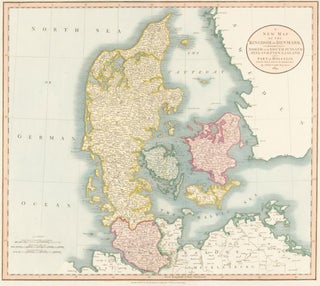
Cary, John.
Cary's New Universal Atlas.
This plate: A New Map of the Kingdom of Denmark, Comprehending North and South Jutland, Zeeland, Fyen, Laaland, and Part of Holstein.
London, 1819.
Original engraving hand-colored at publication.
Sheet size: 21 x 26 in.
Item nr. 50234
Price: $385.00
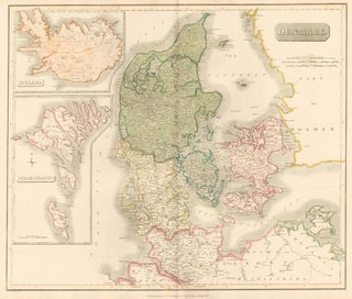
Thomson, John.
Denmark, including the Feroe Islands and Iceland. New General Atlas.
Edinburgh, Thomson, 1817.
Original engraving hand-colored at publication.
Sheet size: 21 x 26 in.
Item nr. 154525
Price: $585.00
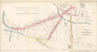
Bardwell, W. and J. H. Taylor.
Report on Metropolis Improvements.
This plate: Detail Plan of the Proposed Thorofares Showing the Houses to be Taken Down.
London, James and Luke G. Hansard & Sons, 1838.
Original lithograph, hand-colored at publication.
Sheet size: 13 1/8 x 23 7/8 in.
Item nr. 161838
Price: $485.00
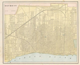
Cram, George Franklin.
Cram's Unrivaled Atlas of the World.
This plate: Detroit, with Toledo on the verso.
Chicago, 1889.
Original lithograph printed in color.
Sheet size: 11 x 14 1/2 in.
Item nr. 159045
Price: $285.00
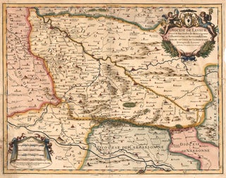
Trinquier, Jean.
Diocese de Lavaur descrit par ordre de Monseigneur...
Paris, 1683.
Original copper engraving on laid paper with early hand-coloring.
Sheet size: 15 3/4 x 19 1/4 in.
Item nr. 158536
Price: $285.00
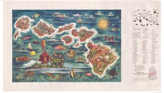
Feher,Joseph.
The Dole Map of the Hawaiian Islands.
Honolulu. Hawaiian Pineapple Company, 1950.
Color lithograph.
Sheet size: 23 1/2 x 41 in.
Item nr. 168646
Price: $1,275.00
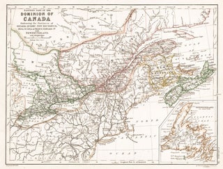
Johnston, Alexander Keith.
The Cabinet Atlas of the World.
This plate: Dominion of Canada.
Edinburgh, W. & A.K. Johnston, 1878.
Sheet size: 9 3/4 x 12 1/4 in.
Item nr. 154055
Price: $300.00
Palmer, Richard.
The Bible Atlas.
This plate: Dominions of David and Solomon.
New York, 1836.
Original lithograph with hand coloring.
Sheet size: 5 x 8 1/4 in.
Item nr. 157437
Price: $400.00
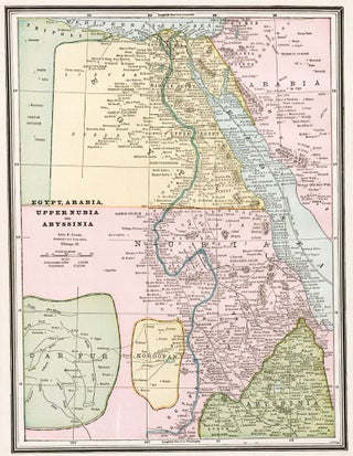
Cram, George Franklin.
Cram's Unrivaled Atlas of the World.
This plate: Egypt, Arabia, Upper Nubia and Abyssinai.
Chicago, 1889.
Original lithograph printed in color.
Sheet size: 14 1/2 x 11 1/2 in.
Item nr. 159085
Price: $285.00
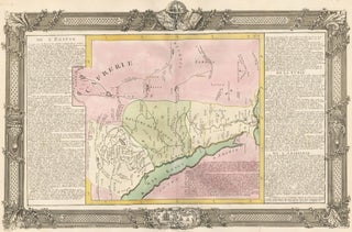
Clouet, Jean-Baptiste Louis.
Géographie Moderne.
Paris, 1787.
This plate: De l'Egipte.
Original engraving hand-colored at publication.
Sheet size: 19 3/4 x 26 3/4 in.
Item nr. 50175
Price: $750.00
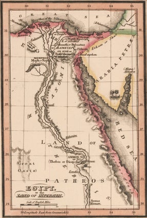
Palmer, Richard.
The Bible Atlas.
This plate: Egypt.
New York, 1836.
Original lithograph with hand coloring.
Sheet size: 8 1/4 x 5 in.
Item nr. 157443
Price: $400.00
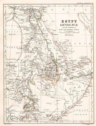
Johnston, Alexander Keith.
The Cabinet Atlas of the World.
This plate: Egypt.
Edinburgh, W. & A.K. Johnston, 1878.
Sheet size: 12 1/4 x 9 3/4 in.
Item nr. 154049
Price: $300.00
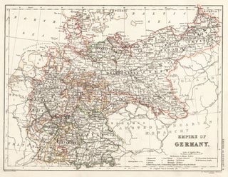
Johnston, Alexander Keith.
The Cabinet Atlas of the World.
This plate: Empire of Germany.
Edinburgh, W. & A.K. Johnston, 1878.
Sheet size: 9 3/4 x 12 1/4 in.
Item nr. 154025
Price: $300.00
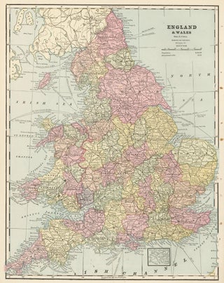
Cram, George Franklin.
Cram's Unrivaled Atlas of the World.
This plate: England, with Europe on the verso.
Chicago, 1889.
Original lithograph printed in color.
Sheet size: 11 1/2 x 14 1/2 in.
Item nr. 159078
Price: $285.00
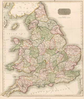
Thomson, John.
England. New General Atlas.
Edinburgh, Thomson, 1817.
Original engraving hand-colored at publication.
Sheet size: 26 x 21 in.
Item nr. 50262
Price: $785.00
Cary, John.
Cary's New Universal Atlas.
This plate: A New Map of Europe.
London, 1808. [Map dated 1804.]
Original engraving hand-colored at publication.
Sheet size: 21 x 26 in.
Item nr. 50249
Price: $785.00
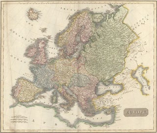
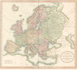
Thomson, John.
New General Atlas.
This plate: Europe.
Edinburgh, Thomson, 1817.
Original engraving hand-colored at publication.
Sheet size: 21 x 26 in.
Item nr. 50276
Price: $685.00